Best Selling Products
Plugin Retouch4me
69 USD

ChatGPT Plus Account (GPT-4)
16 USD
Upgrade genuine Capture One account
120 USD

Genuine Adobe Illustrator account
99 USD
Adobe Photoshop Copyright - Full App
120 USD

Freepik Premium Account
59 USD
Upgrade Genuine Office 365
49 USD

MidJourney Account
29 USD

Windows 10 & 11 Pro Key
36 USD

Genuine Cheap Canva Pro
39 USD

Capcut Pro 1 Year
39 USD

Copyright Adobe Lightroom Account
59 USD

Adobe Premiere Pro Account
99 USD

Upgrade Duolingo Super
29 USD
Autodesk All App Account Copyright
120 USD
What is Autodesk Map? A detailed guide to using AutoCAD Map 3D for beginners.
Nội dung
- 1. What is Autodesk Maps?
- 2. Key features of Autodesk Maps
- 2.1. Connecting and managing GIS data
- 2.2. Support for coordinate systems and geographic data
- 2.3. Editing drawings and geographic objects
- 2.4. Spatial Data Analysis
- 2.5. Data conversion between CAD and GIS
- 3. In what fields is Autodesk Maps used?
- 3.1. Urban planning and land management
- 3.2. Management of technical infrastructure systems
- 3.3. Surveying, measuring and mapping
- 3.4. Environmental analysis and geographic data
- 4. Basic Autodesk Map usage guide for beginners
- Step 1: Launch AutoCAD Map 3D
- Step 2: Create a new drawing and set up the coordinate system.
- Step 3: Connect map data
- Step 4: Display and manage data layers
- Step 5: Edit and update data
- Step 6: Analyze the data and finalize the map.
- 5. What are the differences between Autodesk Map and AutoCAD and Civil 3D?
- 6. Computer configuration for using Autodesk Maps
- 7. Sadesign is a reputable address for Autodesk Map upgrades.
In the fields of map design, urban planning, infrastructure management, and geographic data analysis, accurate information processing plays a crucial role. Conventional CAD drawings are sometimes insufficient to meet the needs of working with coordinate data, existing maps, road systems, or water and drainage networks. This is why Autodesk Map has become a software of interest to many engineers, GIS specialists, and planning agencies. Autodesk Map, often known through AutoCAD Map 3D, offers the ability to combine CAD design and Geographic Information Systems (GIS). The software allows users to work with technical drawings, spatial data, digital maps, and many other data sources in a single environment. If you''re wondering what Autodesk Map is, what features it offers, and how to use it, let''s explore the details in the article below.

1. What is Autodesk Maps?
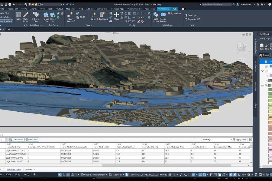
Autodesk Map is a mapping and spatial data management solution developed by Autodesk, integrating CAD tools with GIS data processing capabilities. The most commonly discussed version today is the AutoCAD Map 3D toolset, a specialized toolset within AutoCAD that supports users in creating maps, editing geographic data, managing location information, and performing tasks related to planning and infrastructure.
The highlight of Autodesk Map lies in its ability to combine DWG drawing data with GIS data sources such as SHP, SDF, spatial databases, and raster imagery. Users can work with different data layers, set coordinate systems, display geographic information, and edit objects directly within the familiar AutoCAD environment.
Instead of switching between multiple software programs, Autodesk Maps supports centralized data from various sources, making the workflow more convenient. The software is particularly suitable for tasks requiring high accuracy in location and geographic information, and the ability to manage map data over long periods.
2. Key features of Autodesk Maps
2.1. Connecting and managing GIS data
Autodesk Map allows direct connection to multiple spatial data sources through FDO technology. Users can import data from GIS files, databases, or other geographic information sources into the map for viewing, analysis, and editing.
Connected data can maintain links to the original source, supporting more convenient information updates instead of having to re-enter all the data. This is a useful advantage when working with maps that have multiple layers of information or data that frequently changes.
2.2. Support for coordinate systems and geographic data
The software provides tools for establishing coordinate systems, converting spatial data, and locating objects on a map. Users can select a coordinate system suitable for their work area, ensuring consistent data display when combining data from multiple sources.
This feature is particularly important in surveying, measuring, mapping existing conditions, planning, and managing construction projects. By establishing the correct coordinate system, users can minimize data misalignment or inconsistencies between drawings.
2.3. Editing drawings and geographic objects
Autodesk Map integrates familiar AutoCAD editing tools, supporting users in processing lines, boundaries, areas, points, and many other drawing objects. In addition to CAD objects, the software also allows editing geographic data connected from GIS sources.
This allows users to update geometry, data attributes, and map information according to their actual needs. The editing process is more flexible, especially when dealing with maps containing many objects or requiring continuous adjustments.
2.4. Spatial Data Analysis
The software supports various geographic data analysis tools such as location-based querying, buffer zone creation, data overlaying, and topology construction. These features help users find relationships between objects on a map, identify areas of influence, or check the connectivity of infrastructure systems.
For example, when managing a water supply network, users can analyze pipeline routes, identify areas within their sphere of influence, and find objects related to a specific location. This makes map data more useful in management and planning.
2.5. Data conversion between CAD and GIS
AutoCAD Map 3D supports importing and exporting data between DWG drawings and popular GIS formats through the MapImport and MapExport tools. Users can convert data for design, storage, sharing, or collaboration with other specialized software.
Data transfer capabilities help reduce manual operations, save time, and support the maintenance of information consistency during interdepartmental exchanges.
3. In what fields is Autodesk Maps used?
3.1. Urban planning and land management
Autodesk Maps supports the creation of current status maps, land boundary management, functional zoning visualization, and the aggregation of information for planning purposes. Users can combine population, transportation, topographic data, and other relevant information to gain a comprehensive overview of the study area.
For planning units, the software helps organize data more visually, making it convenient to update drawings and assess changes in the project area.
3.2. Management of technical infrastructure systems
Electricity, water, telecommunications, transportation, and public works management units can use Autodesk Map to store, display, and track infrastructure information on maps. Data such as pipeline routes, power pole locations, cables, valves, substations, or connection points can be managed in layers.
When checking the status or updating project information, users can easily locate and retrieve relevant data, contributing to improved system management.
3.3. Surveying, measuring and mapping
Autodesk Map is suitable for tasks involving coordinate data processing, displaying survey points, constructing topographic maps, and combining information from multiple sources. Users can import survey data into drawings, check the location of objects, and organize maps according to their intended use.
The software also supports displaying data in layers, making maps easier to follow and more convenient for presenting survey results.
3.4. Environmental analysis and geographic data
In the environmental field, Autodesk Map can support the aggregation of regional data, showing the extent of impact, analyzing location, and combining geographic information layers. Data such as green areas, water sources, topography, or areas requiring monitoring can be presented on a single map.
Thanks to its data organization and spatial analysis capabilities, users have a stronger foundation for evaluating, planning, and managing research areas.
4. Basic Autodesk Map usage guide for beginners
To begin working with Autodesk Maps, users should familiarize themselves with the interface, coordinate system setup, and data connection before performing advanced editing or analysis. Below is a basic process to help you get started with the software more easily.
Step 1: Launch AutoCAD Map 3D
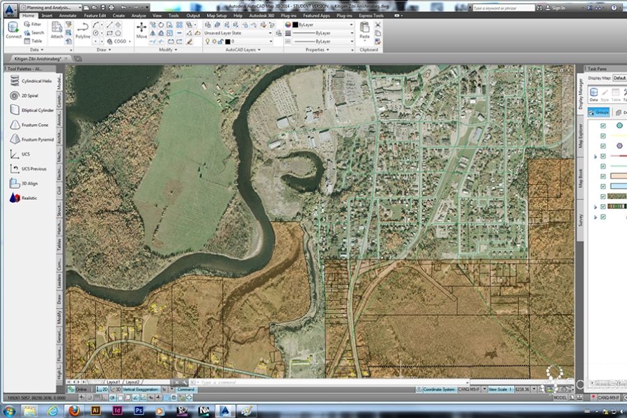
First, install and open the version of AutoCAD that includes the Map 3D toolset. After launching, you can select a suitable working environment, such as the Planning and Analysis workspace, to access specialized tools for mapping and GIS data.
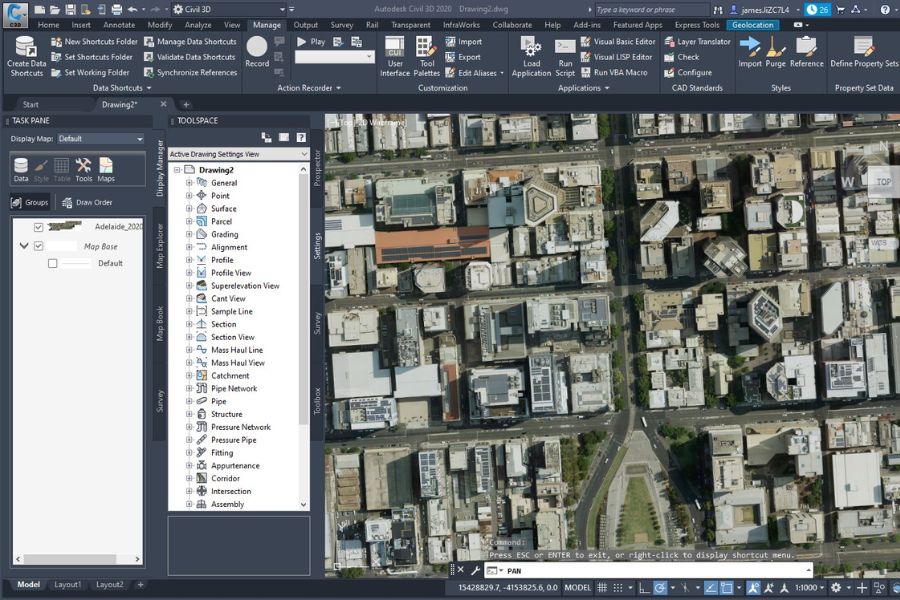
On the main interface, familiarize yourself with the toolbar, drawing area, data management panel, and function panels. Understanding the location of frequently used tools will help you work faster.
Step 2: Create a new drawing and set up the coordinate system.
Choose to create a new drawing or open an existing DWG drawing. Then, proceed to set up the coordinate system suitable for the data and project area. You can search for the coordinate system by code or name in the library supported by the software.
This step requires careful consideration because the coordinate system directly affects the display location of geographic data. If using multiple data sources, verify the coordinate information of each source to minimize discrepancies when combining them.
Step 3: Connect map data
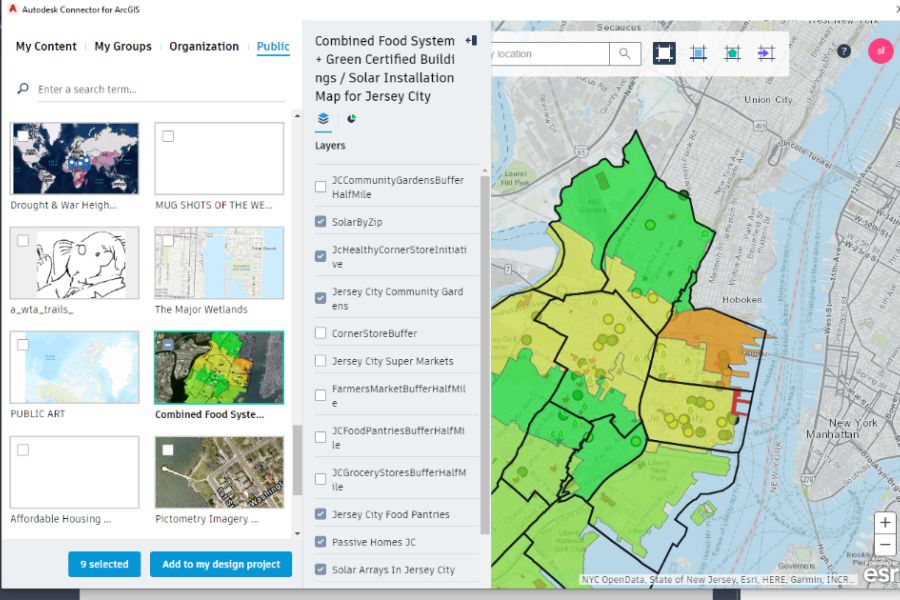
On the working interface, open the Data Connect panel to select the data source you want to use. Depending on the project, you can connect to SHP files, SDF files, spatial databases, or other data sources supported by the software.
After selecting the source, enter the necessary connection information and establish the connection. Once the data is recognized, you can select the information layers you want to include in the map. Carefully check the layer names, attributes, and display locations before proceeding.
Step 4: Display and manage data layers
Once the data has been imported into the map, use the Display Manager to manage the information layers. You can arrange the display order, turn layers on or off, change colors, line styles, line thickness, and how objects are displayed.
Dividing data into separate layers makes maps easier to observe. For example, a planning map can be divided into layers for transportation, boundaries, buildings, residential areas, and infrastructure systems for convenient user tracking.
Step 5: Edit and update data
After the rendering is complete, you can proceed to edit the object as required. Use familiar CAD commands to adjust the geometry or specialized Map 3D tools to update geographic data.
If you're working with data directly from an external source, check how you edit and save changes to ensure the information is updated in the correct location. For critical data, it's advisable to create backups before making major edits.
Step 6: Analyze the data and finalize the map.
Once the data is fully organized, users can utilize analytical tools such as object querying, buffering, overlaying, or topology checking depending on the project's objectives.
Once complete, double-check the coordinate information, attributes, display method, and accuracy of the map. You can set up the print layout, add legends, scale, map frames, and other necessary information before publishing the drawing or sharing the data with others.
5. What are the differences between Autodesk Map and AutoCAD and Civil 3D?
Autodesk Map, AutoCAD, and Civil 3D are all related to engineering design but serve different job needs. AutoCAD primarily focuses on general CAD design and drawing creation. Autodesk Map 3D adds GIS tools, spatial data management, mapping, and location analysis.
Meanwhile, Civil 3D focuses on designing in-depth technical infrastructure such as roads, earthworks, drainage systems, alignments, and cross-sections. Civil 3D has model-based design tools and engineering rules, suitable for the design process of civil engineering and transportation projects.
If your work primarily involves mapping, geographic data management, integrating CAD with GIS, and analyzing spatial information, Map 3D is a suitable choice. However, if you need detailed infrastructure design, route model management, cross-sections, and terrain surface management, Civil 3D will be a better fit. Notably, the Civil 3D subscription package includes the Map 3D toolset, while Map 3D is also available in AutoCAD through its specialized toolset.
6. Computer configuration for using Autodesk Maps
For stable use of Autodesk Map, the computer needs to meet the system requirements of the corresponding AutoCAD version. The actual configuration should be chosen based on data volume, number of map layers, and project complexity.
Some factors that should be prioritized include:
-
CPU: A high-performance processor that supports the processing of design operations and map data.
-
RAM: Sufficient RAM capacity to open multiple drawings, work with GIS data, and minimize lag.
-
Hard drive: An SSD is recommended to speed up software startup, opening blueprints, and data retrieval.
-
Graphics card: Choose a GPU that matches your display requirements and software version.
-
Operating system: Use an operating system that is compatible with the version of AutoCAD you are installing.
7. Sadesign is a reputable address for Autodesk Map upgrades.
To fully utilize the features of Autodesk Map 3D, users need to select the AutoCAD version or Autodesk software package that best suits their work needs. Using a licensed version ensures software access, facilitates updates, and provides technical support when problems arise.
If you're looking for an affordable Autodesk software upgrade service, Sadesign is a great option for individuals, engineers, businesses, and design firms needing support during the registration or upgrade process. When choosing Sadesign's services, users can receive advice on suitable software packages, guidance on upgrade steps, answers to questions during use, and support for account or software-related issues, all in accordance with our service policy.

8. Conclusion
Autodesk Maps is a useful solution for those working with maps, spatial data, and projects that combine CAD with GIS. The software provides numerous tools to support data connectivity, drawing editing, coordinate system setup, geographic analysis, and infrastructure information management. If you work in planning, surveying, land management, or infrastructure, learning and using Autodesk Maps will make your data processing workflow more convenient, intuitive, and professional. Choose the version that best suits your needs, prepare a computer configuration that meets the requirements, and find a reliable upgrade provider to ensure effective long-term software utilization.

















VIP Products






Best Selling Products
Plugin Retouch4me
69 USD
ChatGPT Plus Account (GPT-4)
16 USD
Upgrade genuine Capture One account
120 USD
Genuine Adobe Illustrator account
99 USD
Adobe Photoshop Copyright - Full App
120 USD
Freepik Premium Account
59 USD
Upgrade Genuine Office 365
49 USD
MidJourney Account
29 USD
Windows 10 & 11 Pro Key
36 USD
Genuine Cheap Canva Pro
39 USD
Capcut Pro 1 Year
39 USD
Copyright Adobe Lightroom Account
59 USD
Adobe Premiere Pro Account
99 USD
Upgrade Duolingo Super
29 USD
Autodesk All App Account Copyright
120 USD